A Day In The Life

We begin today at an ungodly hour, 7:30am, because Scott decides it’s a good time to climb on top of the caravan to clean off the bat shit. Yes, you read that right.  One of the more significant differences of our second stay at Mt Isa: the caravan park had a lot fewer travellers but a flock? a wing? a blind? whatever the collective noun is, every night teeming hordes came to hang upside down in the trees and shit all over the place. Which explains the origins of the expression batshit crazy, as that’s what they made us.  

There’s a news item about the number of bats around this season and several people falling ill from lyssavirus, a bat borne disease. I’m keeping a close eye on Scott to see if he develops any signs of paralysis, delirium, convulsions or death, though he’s more likely to injure himself falling off the top of the caravan. If he starts wearing black tights and a mask and talking about saving Gotham, I’ll let you know.

For us, a day on the road does not usually start this early. Many caravaners are up and packed and on the road before we’ve finished our pre breakfast cup of tea. We are rarely on the road before 10.00am, which is technically the time caravan parks want you gone. By now the packing up is routine: disconnect the services – power, water and waste water; empty the toilet cassette, a boy job; close all windows and hatches, take everything off the bench and stow in cupboards – the washing basket placed in the shower is a handy receptacle; take the TV down – don’t forget to wind down the aerial (ok, ok, it was only once); take down and stow any awnings, outside table and chairs; back up the car and hitch up; take off the jockey wheel and put the stabiliser legs up; connect the cables (don’t remind us); attach the safety chains and the weight distribution bars; and a new one for today, remember to empty and put away that last glass of water that you left on the bench.

lovely Mt Isa

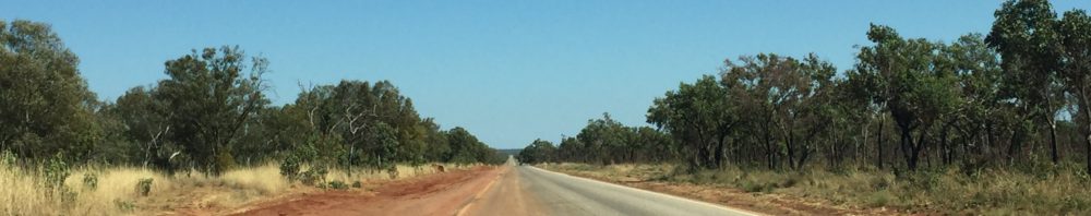
We’ve driven a couple of hundred kms from the dubious charms of Mt Isa to isolated Camooweal – it’s stop here or drive another 260kms to the next stop – and 500kms, while just down the road to an Australian, is a bridge too far for us. Our longest driving day so far has been 440kms, and that was enough. Sometimes it’s the long flat straights that are the most tiring for your concentration. We share the driving and listen to ABC radio and learn amazing things, especially in the Science hour. Go on, ask us how fast you have to go to break out of the Earth’s atmosphere. To their credit, whoever is in charge of road safety does their best to help you maintain your attention.

get the bloody message?

Camooweal, aside from some caves, has little: there’s the obligatory Roadhouse, and it has a caravan park out the back and a swimming pool. It is the electricity and the pool (not together) that clinch it as it is now 35+ degrees every day. Access to a powered caravan site is essential for me as if we don’t run the air con in the caravan I lose my mind. It’s possible we’ve stuffed up in our planning, such as it is. The idea to reach the Centre (Alice Springs and Uluru) in Spring so it wouldn’t be too hot is now laughable.

beautiful colours (and cool temperatures) are the key features of the chamber

We wait til the temperature drops to 34 then drive out to one of the caves. It’s a rough, hot but short clamber down to the wide chamber which was formed by a sinkhole 500 million years ago, give or take. The temperature difference is remarkable – it’s at least 10 degrees cooler down in the chamber – if it wasn’t for the allure of the swimming pool and air con I’d’ve been tempted to sleep there – that and the threat of snakes.

Meanwhile, back at the Roadhouse it’s Saturday night and as lively as a church on Monday. Only two people are interested in the Rugby World Cup pool match featuring Australia against Wales, and those two people are Kiwis and therefore support anyone playing against Australia. We cheer when Wales win – the level of interest from Australians in the bar registers zero on the interestometer.

Just west of Camooweal we cross the border into the Northern Territory and gain half an hour. Here at the Homestead, which is actually a Roadhouse, we’re a long way from anywhere substantial. We’ve still got another 720kms to Alice Springs, and while it looks like it’s nearby, it’s another 470kms to Uluru.

I’m guessing the red means more dust and more heat

Not surprisingly, you pay more for things the further you are from civilisation, or competition. The least we’ve paid for diesel is $1.45 a litre (there’s no road user tax) and at Camooweal we pay the most at $1.82. Here at Barkly it is $2.06.

$6.50 was a lot for a vanilla slice, but it was damn delicious.

It’s so hot now at 2.00pm it’s a toss up whether to fry an egg on the concrete or go for a swim. The air con is working hard but seems to have the cooling capacity of a koala yawning – fortunately it doesn’t smell as bad. Perhaps it’s time for a beer.

City to City

I mentioned we feel a little culture shock arriving in Cairns, with its city atmosphere after our weeks in the outback. However it doesn’t take long to get used to the creature comforts of city living: like decent coffee, even if you do have to specify double shots.

We fall in love with the charms of Cairns and later, 350 kms south, Townsville. The cities are similar in some ways, particularly in that they make the absolute most of their stunning coastal locations, both having fabulous long walking/biking paths extending for kilometres, along with free public swimming pools by the sea front. Yet, the cities differ significantly. Cairns is a party dude – it shouts WOOHOO “let’s do stuff! come see my attractions:  the Great Barrier Reef! The Daintree Rainforest! Fraser Island! Port Douglas!”.

the north end of Townsville, out to Magnetic Island from the top of Castle Hill

Townsville counts on more prosaic economies than tourism – namely defence, with four major defence establishments and 15,000 defence personnel, and manufacturing. It is the only city globally to refine three different base metals – zinc, copper and nickel, and there are plans for a $2 billion lithium-ion battery production facility. Take that you environmentalists. The city is dominated by Castle Hill, a 286 metre high pink granite monolith plonked in the heart of town. It gives stunning views out to Magnetic Island and over the surrounding area, and is popular as a hill running track for freaks and lunatics. We spot several examples on our drive up the hill.

danger – foot traffic

Townsville also has an eye to tourism but without as much to offer as Cairns. We spend a couple of hours at Reef HQ, the excellent aquarium where you can visit the reef without leaving land. We learn about even more things that can kill you. Who knew there’s a deadly sea snail? Not me. The Cone Snail is harmless looking and lives in a pretty shell. But pretty can be deadly: through a harpoon like tooth the snail shoots venom that paralyses. Yes, people have died. Word on the marine biology street is, if it’s a cone, leave it alone.

Cone shells, so pretty to look at, so deadly to hold

Townsville has an arty alter ego as shown by the Council funded Street Art project. A walking trail takes us around 24 commissioned pieces by a mix of world renowned artists – as none of them were Banksy I’d never heard of any of them – and local talent. It is quite simply fabulous.

a small section of a larger work by international artist ROA, who uses native flora and fauna in his work – the full work is about 20 metres long, too big to get in one shot
Mother Earth, by LEANS, a vision of the movement felt when exploring the Great Barrier Reef and Townsville ecosystem

In between Cairns and Townsville lies the Cassowary Coast, so called because it is the home of Australia’s weirdest bird – the Cassowary, but more on that later. There are sugarcane and banana plantations as far as the eye can see. The beaches, particularly Mission Beach, are worth writing home about: long, long stretches of white sand and waving palm trees. You may have caught the news last week revealing a developer has spent $200 million buying properties in Mission Beach as well as another $31 million for Dunk Island – destroyed by Cyclone Yasi in 2011. It explains why, when we rang with an idle query about a beach side vacant site, the agent told us it was under offer for $900,000. How we laughed.

late afternoon at South Mission Beach, looking to Dunk Island

Driving the Cassowary Coast, we see more signs announcing the presence of Cassowary than actual Cassowary. It is surely the Scarlet Pimpernel of birds. Even so, it’s wise to be Casso-wary: it is the largest forest bird in the world – it can’t fly, but it can run up to 50kph, jump up to 1.5m, swim and – oh yes – disembowel you with its dagger like claws.

Are you speeding? Warning to slow down for the Cassowaries you don’t see

So when I finally do see one, I almost fall off my bike in my efforts to catch up and photograph it. Stealthy David Attenborough I’m not.

the Cassowary – large, ungainly and potentially lethal if provoked

While we are in the heart of sugarcane country we take the opportunity to go to Tully a nearby sugar cane mill which annually produces about 260,000 tonnes of raw sugar for export. You know how you go places and they give you safety gear and you wonder why – this tour is the exception. We are taken through a busy noisy, dirty factory that shows us everything from the cane train arrival to the raw sugar being loaded onto trucks to go to the coast for export. It takes about eight tonnes of cane to produce one tonne of raw sugar. They don’t say how many tonne to give you diabetes.

cane train arriving at the mill

It is amusing to find Tully prides itself on being the wettest town in Australia with an average annual rainfall of 4,000mm. Of course it wouldn’t be a small Australian town if it didn’t have a giant artefact: what would you build to declare your town’s rainy fame? What about a golden gumboot? I would so like to have been at the meeting when that decision was made.

Tully’s tribute to rainfall

It must be apparent by now this blog is not real time. Since Townsville we’ve driven the Flinders Highway through Charters Towers, Hughenden (more dinosaurs) and Julia Creek. Today finds us back at Mt Isa – a different, quieter town from when we were here for the rodeo six weeks ago. We’re at the same Caravan Park, but instead of over 100 sites in occupation, there are a dozen. Instead of a temperature of 25-26 degC it’s now 34-35. We’re hot – damn hot. We were looking forward to heading south to Alice and Uluru for cooler weather but I see it’s heading for the mid 30s there too this week. I’ll be a grease spot on Uluru.

Every Day is a Winding Road

As we are learning, driving the long distances in Australia isn’t always long flat stretches of termite mounds, wandering stock and red dust. Sometimes there are craggy knolls, winding paths over ranges and even hills, but so far no mountains.

thousand of termite mounds speckle the landscape

We leave the barramundi barren rivers of Normanton and head east along the Savannah Way towards Cairns. There isn’t much to capture interest for the first 300kms except for a surprisingly decent cup of coffee in minuscule Croydon (population 258). The guy serving us had worked at Parrot Dog Brewery in Wellington – talking to him is the nearest we’ve come to a decent craft beer since we’ve been here. At Georgetown (population 328) we turn south to an even smaller settlement at Forsayth (population 129) so we can visit to Cobbold Gorge down another 45km of dirt road.

The family that owns the property had lived on the station for years before discovering the gorge, and it’s young geology – only 14,000 years old. They have wasted no time in developing a tourist attraction. The gorge tour start with a 4WD truck ride for 15 minutes across a dry river gulch and lumpy bush tracks; an hour’s walk up on to the limestone escarpment above the gorge follows. The guide treats us to frequent stops to describe the traditional uses of different plants and bush tucker, none of which I would recognise again, except for a small red berry commonly known as the Rosary Pea. It packs a deadly poison called Abrin – identical to Ricin (remember the umbrella tip assassination?) but toxic by two orders of magnitude. And we were worried about snakes.

the narrowest part of the Cobbold gorge

The gorge goes from narrow to very narrow, being only a couple of metres wide at some spots.   We see a few fresh water crocodiles sunning themselves on the boulders, but they aren’t bothered by us sliding by in our electric boat. You can only imagine how fast the water powers through such a narrow space in the wet season.

croc on a rock in the Cobbold Gorge

As we continue our trip east towards Cairns we don’t realise we are steadily climbing on the Tablelands until we reach Ravenshoe, where a sign proudly announces it is the highest town in Queensland at 930 metres (3,050 feet). From there the road descends rather more steeply and more windily than the ascent.  It was a beautiful, if heart-stopping, drive towing a caravan on one of the windiest roads we’ve ever been on.  Anywhere. 

it’s a long and winding road

Unfortunately I’d driven the first half of the trip so I had to listen to ongoing refrains of “these turns are tight” and “I wonder if there was another road” and “this’d be great on a motorbike”, while mopping the brow of the driver.

It transpires there is another road further north, the one the sensible people towing caravans take. The one we are on – thanks Nav – the Gillies Highway, we learn is to close over the upcoming weekend for the Targa rally: the 22km section with 612 bends is among “the most exciting roads in the country” for rally racing. We know why. We are now fully prepared to enter a caravan sprint over the Swiss Alps.

this is the car to drive the Gillies Highway – note is isn’t towing a caravan

As we transverse the Atherton Tablelands, we drive through dairying country, and it feels like home seeing Friesian cows grazing in paddocks, instead of Brahmins foraging through scrubland. Then as we hit the flat land it all changes again and we drive through acres of sugarcane farms. Arriving in Cairns is a minor culture shock after the small outback settlements along the Savannah Way. I mean, there are traffic lights and double lane roads. And buildings several stories high.

I hope you can follow the black line – best I can do

Here’s a map of our progress to date. The bottom circle around the New South Wales/Queensland border is our initial trip, and the spot closest to the border is Stanthorpe, where we stayed with friends on their vineyard, and which is now the area ravaged by fires. North of Tweed Heads through to Cairns is the current progress.

We’re now slowly working our way down the beaches from Cairns to Townsville before turning west again towards the Centre. We’ll take the Flinders Highway then turn left when we get to the Stuart Highway which runs from Darwin to Adelaide. This is the sort of country where people disappear, get murdered, and die of stupidness, so stay close to your favourite news station – we may become famous.

Talking Fishing Blues

As most of you know, Scott – aka the hunter-gatherer – loves fishing, or more specifically catching fish. Catching a barramundi is on his list. Sadly a lot of his efforts this trip are what he describes as casting practice. I estimate to date about a $500 spend on a couple of fishing charters and boat hire; the elusive barramundi remains elusive. On the plus side, that money has covered a site-seeing/fishing helicopter flight, a day’s boat hire in a beautiful, beautiful place, and a big catch of blue salmon.

Not often you take a helicopter to go fishing, but this is north Queensland and the rivers run a long way inland

From Mt Isa we backtrack a little to Cloncurry, then head north to Karumba, a small settlement of about 530 people on the the Gulf of Carpentaria. The only stop on the Matilda Way between Cloncurry and Normanton, just south of the Gulf, is the Burke and Wills Roadhouse. It gets very busy with caravaners, road trains and campers as there isn’t another stop offering fuel, fried food, terrible coffee, and very dusty campsites over this 400km stretch.

A dubious oasis
a very apt description

The road becomes narrower and narrower as we get closer to Normanton and then Karumba which bills itself as the outback by the sea. There are long sections that are single lane; when you see a massive road train coming towards you it’s wise to take to the side as they certainly won’t. You can’t blame them in the wet season when the shoulders will be all sludge and mud, and at hundreds of tonnes they don’t want to get stuck. But guys, this is “the dry”, move over just a little won’t you?

the single lane road narrows as you get further north

The Gulf is so vast and so shallow there are only two tides a day. This is the first fishing charter – no barramundi but they caught loads of Blue Salmon – not a salmon as we know it, but a firm white fleshed fish that cooks well and tastes good. They were fishing in only a couple of metres of water.  To get 20m of deep water you have to go 60 nautical miles (three times across Cook Strait).

Blue Salmon and an ice bottle

The compensation for no barra is stunning sunsets. In this part of the world the sun slowly slides to the horizon then BAM! It’s gone, and 10-15 minutes later the most beautiful colours paint the sky. We take a trip out to a sand island – remember it’s all very shallow – for sunset drinks, and it is as if there’s no-one else in the world – aside from the other 15 people on the boat of course.

next stop, New Guinea

The heli fishing charter out of Normanton is worth it for the view of the landscape alone. It’s extremely flat so it’s difficult to grasp the magnitude when you are driving through, but from the air you see and fully appreciate the expanse. The Flinders, Leichhardt and Norman Rivers, among others, drain into the Gulf and take long winding routes to get there. Scott is fishing the Norman and the system amazes us with its multiple twists and turns – and the crocodiles sun bathing on the banks. Chris, the pilot/fishing guide tries his best and takes Scott to several different places on the river, but some days the fish don’t bite. The crocodiles bite every day.

the long and winding Norman River

Now we are back on the east coast we hire a small boat for the day and spend it out and about the islands off Mission Beach. It is a glass calm day and the temperature is about 30 degrees, water temp probably about 22. We try trolling with a lure; we try bottom fishing with bait – no bites.

hard out fishing
serious work this driving the boat

Never has the hunter-gatherer had such a stretch of poor fishing. Fortunately we enjoy exploring the islands and swimming off the beach at Dunk Island so the day is still perfect – except for the lack of fish. Fortunately for us the fish and chip shop is always open.

The Big Barra at Normanton – so this is what they look like